Reading Through Time: The Landscape of Greater Cahokia
John Kelly
The focus of this itinerary is on the American Indians who lived and thrived in the American Bottom region of the central Mississippi valley. People have lived in this region for well over a dozen millennia. As an archaeologist, I can measure that distance in the past; however, one must acknowledge that they conceive that they have always been here. We must imagine, and this concept is extremely important to our purposes, what it must have been for the first people in the “New World” to arrive when it was very cold and a barren landscape in many places. But once away from the tundra, forests appeared much like one still sees in parts of Canada. Then as now, the Mississippi valley sliced through the heart of the North American midcontinent; however, vast quantities of water covered the val ley from bluff to bluff as the thick ice sheets further north dwindled with the warming climate. Plants, animals, and people were responding to these changes.
At the heart of these evolving palimpsests of the environment was the Mississippi River. Not that everything was dependent upon it. Rather, it was a force to be reckoned with when it swelled with rains saturating its basin—extending north into the western Great Lakes and especially northwest, where the origins of its largest tributary, the Missouri River, began its life.
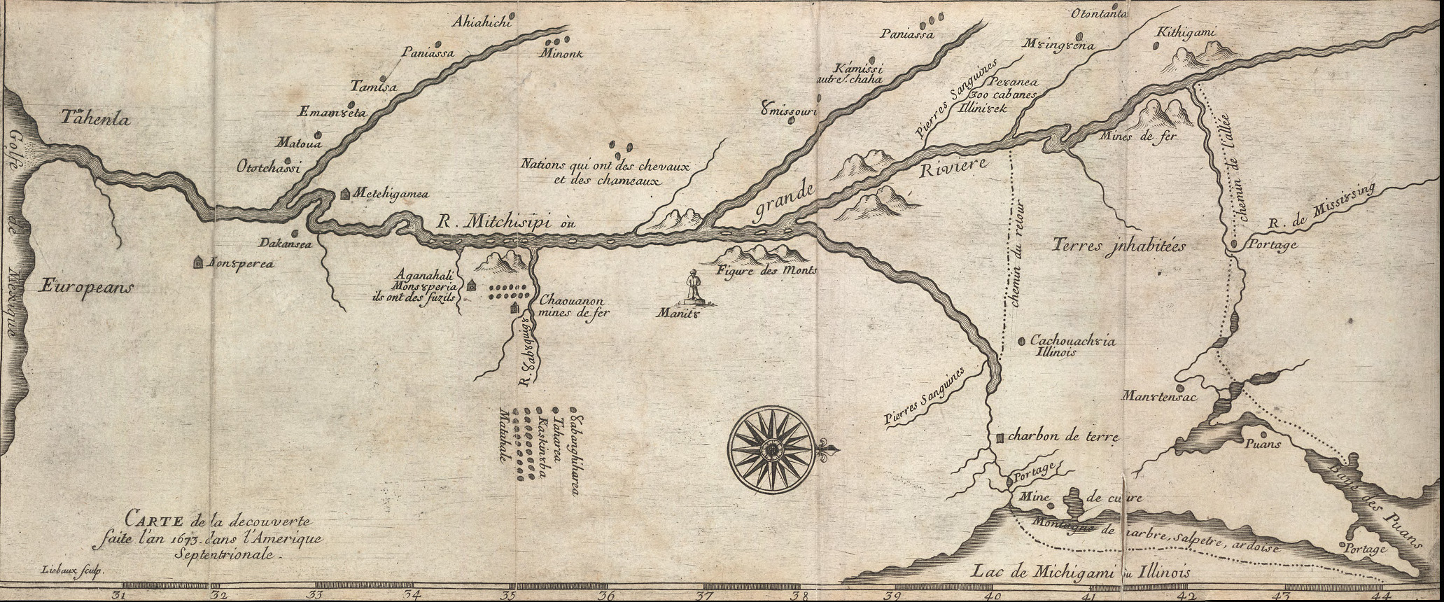
Marquette and Joliet map, 1681 [north to the right].
Identifying Figure des Monts (or "Mountain Shapes") at the Missippi and Missouri confluence.
I was fortunate a few years ago to see where the Mississippi begins its long journey from a beautiful, lush area of forests and lakes. Like a serpent, the Mississippi meanders sinuously south, past its meeting first with the Illinois River and then with the Missouri. We can still see remnants of this serpentine course in its abandoned channels, such as Horseshoe Lake, Grand Marais, and Goose Lake, as it extended from one part of the valley floor to the next and back and forth until it gradually reached the Ohio River. Indigenous people adapted to this plentiful landscape, where they engaged the various forces of the Earth Mother, and envisioned spirits as important sources of power. Native groups such as the Osage and Omaha referred to this force or power as Wakanda; other indigenous people had their own unique word for this force. Not only was the area rich in food for sustaining life, then, but it also provided a spiritual sustenance that reinforced a view of the larger cosmos—a place constantly striving for balance as the world and people would start to teeter.
The first few millennia after the massive pool of water from the glaciers was gone, people inhabited the landscape focusing on the food resources for maintaining life. It was not a crowded place. People could freely move about the landscape—though they did so not in a random or haphazard fashion, but in one that reinforced their embeddedness in that landscape. They were in constant rhythm with the seasons and rapidly understood the earth and the creatures that were part of this place.
Some six to eight thousand years ago, the warm period known as the Altithermal resulted in the development of prairie ecosystems in a wedge from the eastern slopes of the Rockies east across the Midwest toward the other chain of mountains, the Appalachians. For the area around what would become St. Louis, especially the higher upland areas called the bluffs, tallgrass prairie and, in other occurrences, oak savannas, were scattered across the landscape. Peoples inhabiting the area adjusted to the changes in the environment. Toward the end of this period of relative drought we start to see plant domestication and the cultivation of crops such as sunflower, gourd, and squash. In the latter case, its origins were to the south in Mexico. Wild plants and animals remained important in the diets of the people and were still so when Europeans arrived in the late 1600s. The domestication process, however—more than likely by the women in these societies—demonstrates a sophisticated understanding of each plant’s natural properties and the processes effecting certain plants’ reproduction.
As people became increasingly attached to the land that they and their ancestors had traversed and subsequently, less mobile, the death of familial members—a part of the cycle of life began to be recognized by their interment. This took the form of constructed earthen mounds, sacred blankets not only to cover the deceased, but also to honor the ancestors and the landscape upon which they had lived and died.
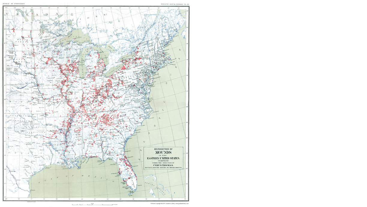
"Distribution of Mounds in the Eastern United States", by Cyrus Thomas. From Bureau of Ethnology, 12th Annual Report, 1894.
Mounds are distributed all across the Eastern Woodlands, from the Great Lakes to the Gulf of Mexico and from the Atlantic Ocean to the high prairies of the Great Plains (Figure A). In parts of Louisiana the people began as early as five thousand years ago to reshape the landscape with earthworks that captured their vision of the cosmos and the world of which they were very much a part. A much larger rendition of these sacred landscapes was created over three thousand years at a place now called Poverty Point in northeast Louisiana. A series of parallel and nested raised earthen rings form a semi-circle (Figure B) overlooking the broader Mississippi floodplain to the east. An earthen mound, estimated as the second largest in the Eastern Woodlands, was rapidly constructed at the western apex of this ring. Rising like a mountain, its apex is a point within this ancient cosmogram that honors the sun’s journey during the equinoxes. This bird-shaped mound is at the place where the sun sinks below the horizon as darkness descends upon the landscape—the place of death. It sits at the balancing point of life and death, but also of that time in the year when the sun will begin its journey south for the winter and north for the summer. Taken as a whole, this landscape symbolizes their cosmos.
Raw materials were obtained from parts of the Eastern Woodlands, including the siliceous rock chert used in fashioning chipped stone implements—primarily employed in the hunting of animals along with the cutting and shaping of other organic materials. The styles of spear points were shared over an area that extended from the western Great Lakes to St. Louis and as far south as Poverty Point. Although differences existed in other aspects of their material culture, people interacted over a broad area, making spiritual journeys or pilgrimages to special and sacred places such as Poverty Point, continuing up to and past the point of contact with Europeans for well over three thousand years. Over this time span, similar sites accentuated by large earthen mounds and enclosures were constructed and appeared in different parts of the Eastern Woodlands, including a place we today call Cahokia Mounds.
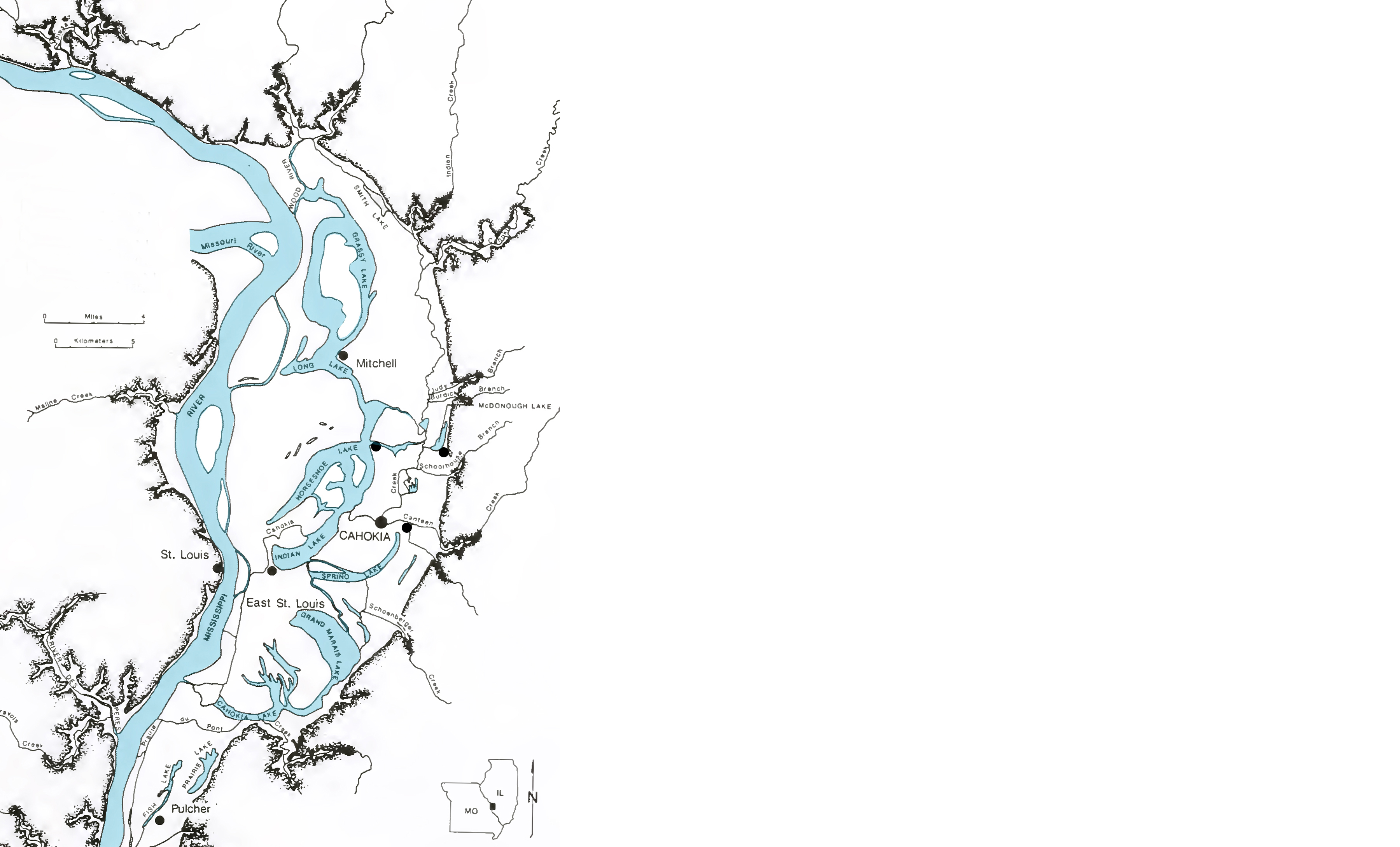
Map of the American Bottom showing historic river meanders and sites associated with Greater Cahokia.
Map courtesy XXXXXX, redrawn by Jesse Vogler
One of the major changes in region’s environment some five thousand years ago was a shift in the behavior and position of the Mississippi River from a meandering serpent to a much straighter course westward in the valley, woven with side channels like braids in the hair, that allowed people to safely travel the river. However, the earlier meandering left numerous abandoned channels that became luxurious lacustrine waters located on a much higher portion of the floodplain, which was not as prone to flooding.
A millennium before Cahokia’s creation, people inhabiting the area were part of a culture archaeologists call Middle Woodland. In many respects, Middle Woodland culture was the climax of building earthworks. Perhaps the most elaborate earthworks were in a section of the Ohio River Valley in the southern part of the state of Ohio. Covering large portions of the landscape, rectilinear and circular enclosures were connected to each other in a way that represented the union of the cosmos between male and female and the ensuing balance achieved (Figure C). Most had a lunar orientation that captured the forces of the moon in its association with the feminine side of the cosmos. Shrouded in the night skies, the moon was a powerful force that complemented the sun. These were societies actively engaged in the cultivation, harvesting, and consumption of native crops. The people were scattered across the landscape much like in the rural farming landscape today, with families residing in small hamlets or villages. The places they created were to situate themselves within their vision of the cosmos.
People in the St. Louis region were undoubtedly connected to and visited the ceremonial centers in Ohio. Throughout the St. Louis region and beyond, large mortuary mounds were constructed upon the bluff crests overlooking the valley as well as in the valley itself. As with their cousins in Ohio, people were horticulturalists. This pattern of plant husbandry continued well after the large earthworks were no longer being constructed.
We will now begin a journey to Cahokia that will take us through various temporal portals. As we enter one community, we exit it through its center—eventually reaching Cahokia. The four or five centuries prior to Cahokia’s development, area residents were focused on agriculture centered on native crops (Figure D). These crops planted in the spring entailed labor-intensive efforts to harvest the seeds in the late spring and fall. A variety of social and technological changes in areas such as cooking technology—especially the pots—paved the way for gradual population increases. People were dispersed across the floodplain and into the uplands in small settlements, much as they were in the eighteenth century with the arrival of the French and other immigrant populations. Occasional villages appeared, but these small communities generally remained intact for less than a decade. What precipitated their moving is still not clear. In similar situations historically, this process of abandonment could relate to any number of factors such as the exhaustion of local firewood, decrease in crop yields, or even the death of a community member. Regardless, it was simply a matter of relocating to a nearby landscape that met their needs. It is estimated, based on excavations, that the population density was approximately 10 people per square kilometer. There was sufficient space to accommodate any changes in settlement location without any conflict.
To deal with the intensity of harvesting the seed crops, presumably all members of a family and the community participated. Increasing the population numbers may have necessitated women weaning the children at a younger age. This process would have been enhanced by the nature of the seed crops themselves, from which they could prepare gruels that could be fed to infants. Pots were designed in such a way that they could be easily used to prepare these foods. Regardless, the population did begin to increase within a century or two to a point where it doubled, and even tripled, from 10 people per square kilometer to 20, and then 30, people per square kilometer. Part of the increase can be attributed to populations once dispersed throughout the floodplain and uplands coalescing on the floodplain and the adjacent bluff. We can now envision a landscape characterized by small villages with upwards of 50 to 100 people. Each village was laid out according to one of three types of basic plans related to each community’s center. These were micro-cosmograms that incorporated specific components of the cosmos and society.
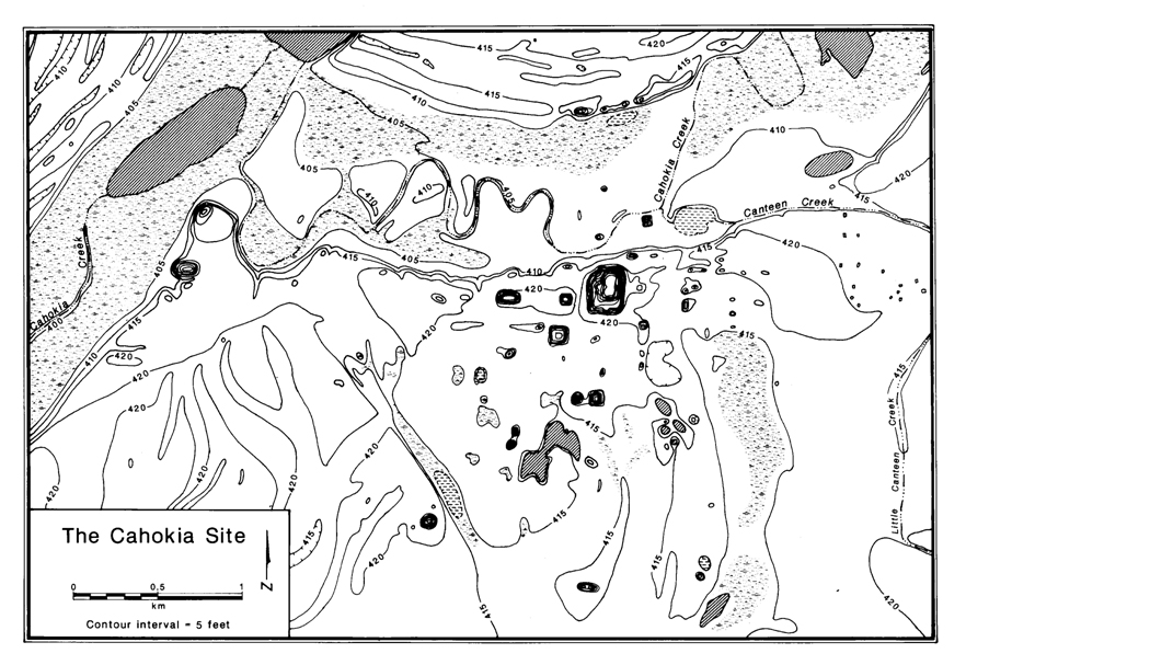
The Cahokia Site in its geographic and topographic context.
Map by XXXXXXX
For each community, a small plaza or community square at its very core had small, rectilinear houses distributed around its margins (Figure E). At the center of some communities was a small post, an axis mundi. Such posts were extremely important historically to native peoples and were often at the center of communities throughout the Eastern Woodlands. In other community plans, the post had four rectangular pits arranged in a quadripartite manner around it. Four is a sacred number that acknowledges the four sacred cardinal directions. The pits would have contained some of the stored grains, including possibly corn, which had been introduced to an already rich suite of seed cultigens. Corn did not become a dominant crop until after the end of the twelfth century. The final plan, which is not as common as the other two, features a large, square, central building. Historically, the Osage’s sky chief for the upper world, or sky, moiety came from a sub-clan referred to as the House in the Middle.
It is important to note that these societies in the region form a complex we call Emergent Mississippian, which within a period of less than two centuries makes the transition to Mississippian. The population continued to increase to a density of 50 people per square kilometer. By the end of the tenth century, the smaller villages had started to nucleate into larger villages, each covering about one hectare of area with population between 200 and 300 people (Figure F). Within a few decades people at these outlying villages surrounding Cahokia rapidly came together at a place we now call Cahokia Mounds. Their settlements focused on an area, some 100 to 200 meters back from the natural levee bank, associated with an abandoned channel of the Mississippi River called the Edelhardt meander. This occupation stretched from the area of the Woodhenge east at least 400 meters to east of Monks Mound. The area encompassed 17 to 34 hectares with a possible population of between three and seven thousand people. Why? Why at this place we call Cahokia? And how?
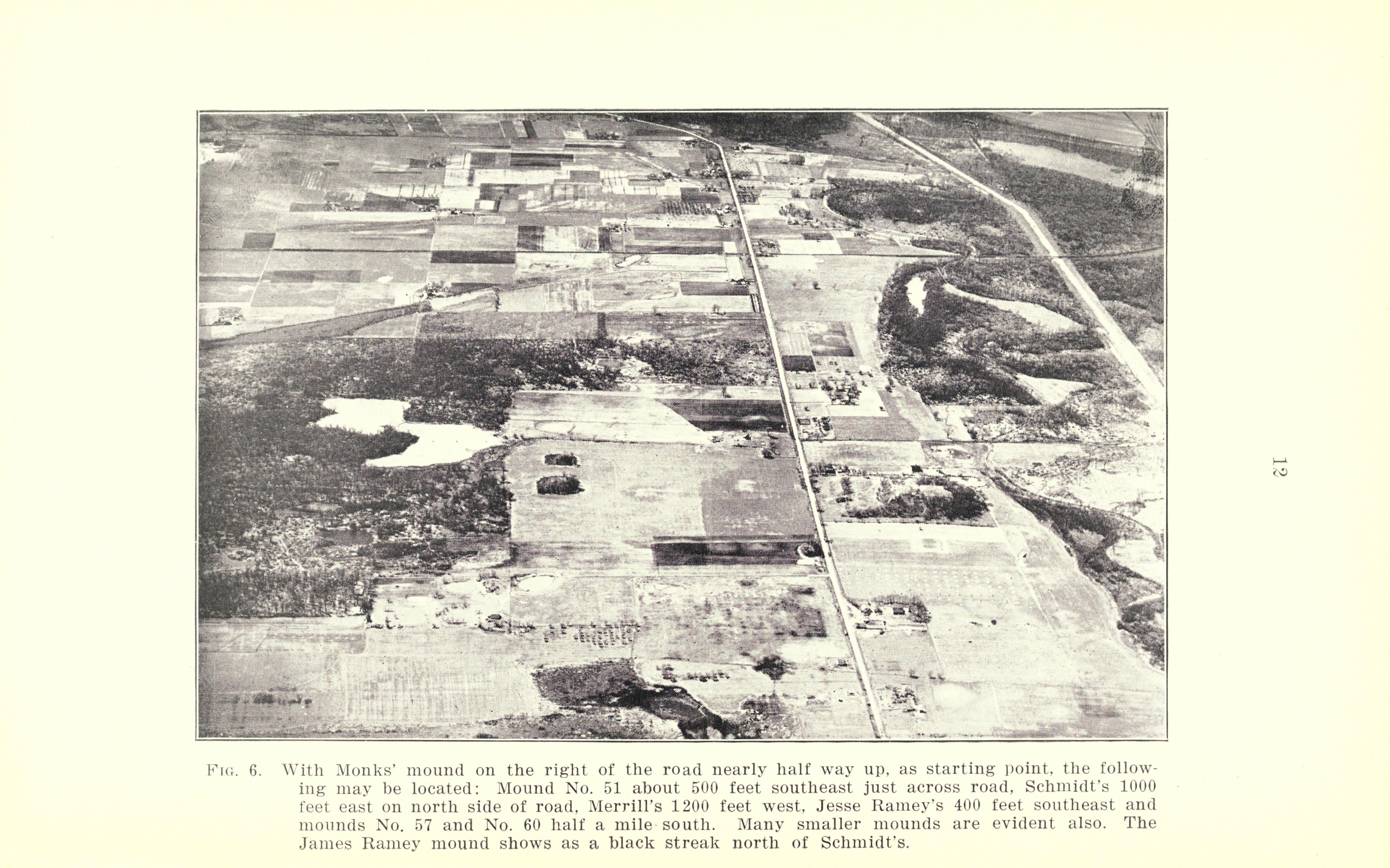
Aerial view looking west.
Plaza at center of photo, with borrow pits visible to the left.
From The Origin of the Cahokia Mounds by A. R. Crook, 1922.
To grasp what the attraction or attractions may have been, we must first understand what and how we define what we call Cahokia as a place on the landscape. Toward the end of the eighteenth century, a French trading post known as Cantine was operational in the area east of the “Great Knob,” which became known as the Great Cahokia Mound and now Monks Mound. Originally, Cahokia Mounds were called the Cantine Mounds at the beginning of the nineteenth century because of the numerous mounds in the vicinity of the trading post. The largest mound was called the Great Cahokia Mound because of the Indians living on the first terrace. Later the Great Cahokia Mound became Monks Mound (Figure G), named after the Trappist monks who lived in the vicinity of the large mound for several years shortly after the onset of the nineteenth century. The rest of the mounds in the vicinity of Monks Mound were then referred to as Cahokia Mounds.
The boundaries employed to delimit the Cahokia Mounds State Historic Site are to a large extent arbitrary, as they are with most places what we call “sites.” How people in the past viewed their places of residence and sacredness have been lost in the midst of time. This does not preclude our still trying to approximate what might have been.
We must also understand the nature of the natural landscape, and what aspects stand out. The Mississippi floodplain, of which this site is a part, represents a mosaic of contrasts. The distinct, broad, and low-lying meander scars I spoke of earlier accentuate the way in which the movement of water in small, incised channels and rivulets serve to connect the various parts of the floodplain.
Cahokia’s landscape is draped across an area of the floodplain that includes two abandoned meander scars. A much older channel known as Spring Lake is superimposed by the more recent Edelhardt meander. The very center of Cahokia straddled these aquatic features, which were rich in fish and waterfowl and some aquatic plants, especially during the spring and fall periods of migration. Spring Lake was a more massive area of water, while the Edelhardt served as a low-lying basin where Cahokia Creek meandered as it made its way from its source to the north in the upland prairies. As this serpentine body of water entered the site, it moved west and then south, where it eventually joined the Mississippi River. At the very heart of the region, Cahokia Creek served as one of the primary transportation routes connecting the numerous towns, villages, and farms on the bottoms. Dugouts would have been one of the primary means of transport on the waterways.
The other transportation mode was on foot. Another important component of Cahokia’s location was an extensive and relatively continuous area of high ground that followed a geographic area known as Helms Ridge. This area extends from the colluvial fan at the base of the bluffs just east of Cahokia Mounds, merging with the natural levee of the Edelhardt meander where Cahokia Creek is located. This elevated portion of the landscape connects to a portion of the Horseshoe Lake natural levee that stretches to an area overlooking the lower terrace of the valley above the lower reaches of Cahokia Creek and the Mississippi River. This route coincides with the location of today’s US Route 40, known as the National Road.
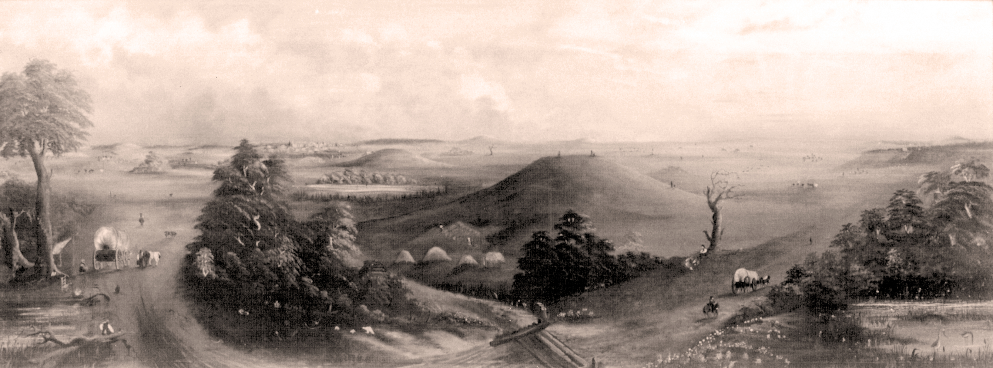
19th century view across the floodplain.
Engraving by XXXXXXX
The connectivity by water and land represents an important part of the region’s infrastructure, facilitating interaction. The importance of this transportation infrastructure is enhanced by the area to the south of the Cahokia Creek drainage catchment on the bottoms, where a number of superimposed abandoned channel scars, Grand Marais, and Goose Lake have resulted in a vast array of aquatic areas. While not precluding interaction of Cahokia and its satellite communities with populations to the south, these areas did limit human occupation of this seemingly vast, watery world.
This spatial dissonance resulted in much greater social distances, which, in turn, resulted in very distinct material differences and cultural identities extending back several centuries between those living to the north in the Cahokia Creek drainage and those living to the south of Prairie DuPont Creek and the various oxbow lakes.
Thus one can imagine in the Cahokia locality a series of overland trails that connected many of the larger communities in the region, and the watercourse along Cahokia Creek and its tributaries that naturally drained a substantial part of the northern floodplain. The ease with which people could readily move about the bottom facilitated the ability to access Cahokia and the larger settlements. Furthermore, the distribution of soils and aquatic resources were such that each community, regardless of its size, had ready access to most of their subsistence resources.
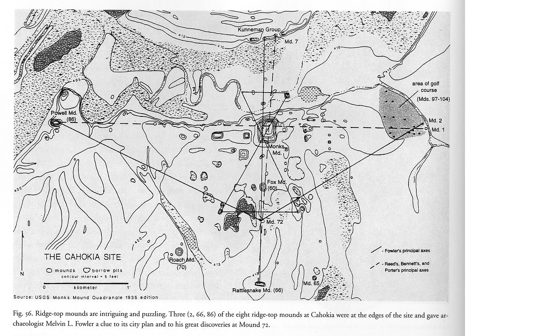
Major alignments of Cahokia.
Map by XXXXXXX
When we turn our attention to the various communities—particularly Cahokia—and how its inhabitants shaped the natural landscape to reflect the cosmos, we begin to better conceptualize the site and its configuration. Today it appears as a static place where we attempt to capture what was; in the past, it was a dynamic and fluid landscape of human imagination and interaction.
We can begin to see how this place began to rise and literally erupt out of the prairies and aqueous world in which it was immersed. The seemingly sudden nucleation of population at the outset of the eleventh century may very well coincide with the appearance of a bright object just above the horizon of the southeastern skies early in a spring morning of 1006 CE. Other than the moon, it was brighter than any other object in the night sky. For three years it hovered above the horizon. Perhaps it was this striking event, interpreted as a sign to come together, that led to the rapid consolidation of people from villages in the area to Cahokia. Homes were constructed along Helms Ridge, from the area where the woodhenge would be built for a distance to the east of nearly two kilometers, and extending back from the edge of the Edelhardt meander bank edge for a distance of between 100 and 200 meters. This area of occupation, estimated to be between 17 and 34 hectares, may have accommodated between three thousand and seven thousand people.
It was extraordinary! Houses were constructed and, as in their recently abandoned ancestral villages, arranged around courtyards and small plazas. We have no evidence of mounds, although small mounds were being constructed within the region. We do, however, begin to see the movement of earth in the design and creation of four large plazas that demarcated Cahokia’s epicenter. At the north end of the East Plaza the upper 30 to 40 centimeters of earth were removed, exposing the light-colored earth below. The front of the bank of the natural levee was removed, and a terrace was created nearly two meters below, upon which houses were built. We have no indication as to where the earth removed was destined. Shortly thereafter a low (less than a meter in height), rectilinear, platform mound was erected. The north face of this small, earthen platform extended over the bank covering the filled-in basin of a house that had been constructed on the terrace two meters below. Other low platform mounds were present within and along the margins of this plaza, and it is possible the earth was destined for these places. At the south end of the plaza, a large borrow area was excavated—and then rapidly filled with debris from the preparation of what was an undoubtedly a large feast nearby.
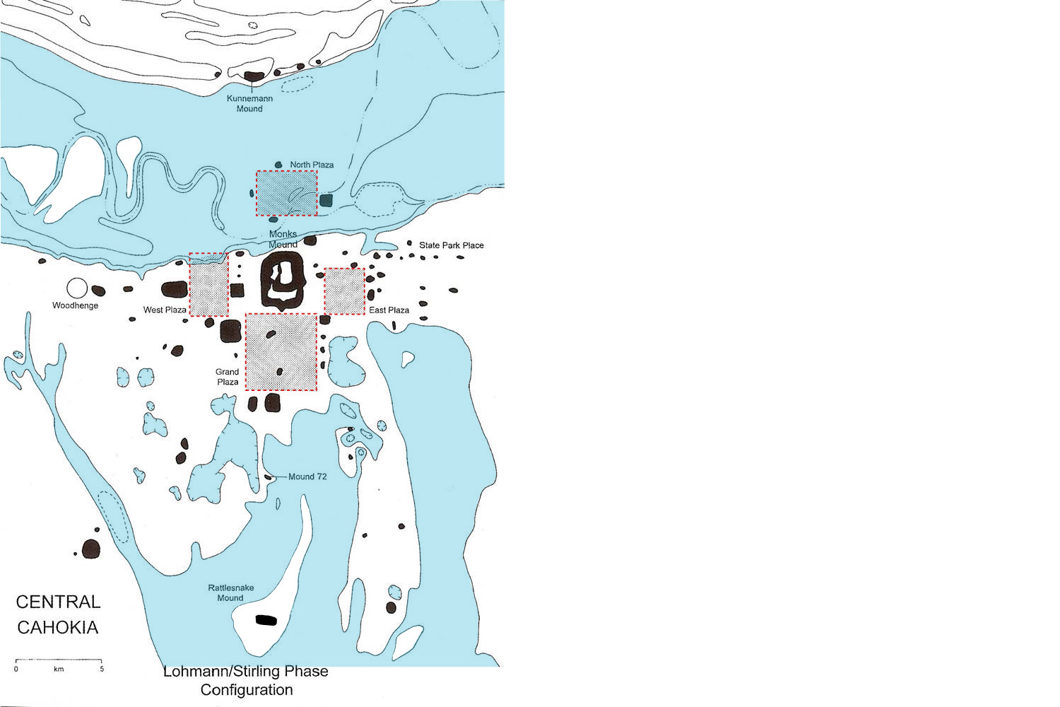
The four plazas of central Cahokia
Map by XXXXXX, redrawn by Jesse Vogler
This borrow pit also extended into the very northeast corner of the Grand Plaza, the southernmost plaza. Prior to its creation, this area was an uneven, natural landscape of ridges and swales that the ancient channel of the Mississippi River created over five thousand years ago as part of the Spring Lake meander to the east. Remnants of the more sandy ridges still can be seen outside of the Grand Plaza. It was here that the tops of the sandier ridges were truncated with the earth deposited into the adjoining low-lying, clayey swells. This level landscape was then accentuated as a sunken plaza by the creation of platforms of earth to the east, south, west, and north. The easternmost platform covered the borrow pit, and eventually a mound was constructed upon its summit. In this way, the four sacred directions played a role in shaping this landscape. Now the plaza was visually—and symbolically—lower.
What we readily see today are the pairing of mounds around the plaza’s periphery, placed in opposition and reflecting the basic geometric forms of the circle and the square. Throughout Cahokia the square is on the east or south, complemented by a circle on the west or north, respectively. If we peer below the large, rectilinear Murdock Mound at the south end of the east row of mounds, excavations have uncovered structures placed in the same relative position. These shapes reinforce basic principles of duality that underscore the balance achieved within the universe. The lowest piece of architecture in this sequence is a cross-shaped house placed within a circular basin. Moreover, we can easily see in some instances the pairing of big with little.
If we turn our attention to the West Plaza, its leveling was not as massive as that of the Grand Plaza, but comparable to what was occurring with the creation of the East Plaza. Again we see the pairing of mounds to delineate three of the plaza’s sides, the fourth, northern margin left open to swampy wetlands that symbolized the watery underworld of their cosmic model. Unlike in the East and Grand Plazas, where a few mounds were placed within the plaza, none are evident in the West Plaza. Instead, large circular and rectangular enclosures were placed at the north end of the plaza to form a north-south axis through the plaza’s center. This architectural sequence begins with a series of large, circular enclosures. Then one of the large, square enclosures with small, circular rooms along its outer walls is paired with a large, circular rotunda. Along this axis to the south, four large poles rising some twenty feet into the sky were placed to honor each of the four sacred directions at the plaza’s center.
At the very center of this tableau of spatial architecture was Monks Mound. However, its construction rapidly occurred after the four plazas had been established. The landscape upon which Monks Mound was constructed was the site’s architectural and cosmological axis mundi. Monks Mound, once underway, was to a large extent constructed of earthen materials derived from the meander scar to the north. The massive depressions that the extraction of earth would have made are no longer visible, because the abandoned channel was a basin in which sediments from the Cahokia Creek’s periodic flooding rapidly accumulated over the millennia. These creative events, taking place throughout much of the eleventh and into the twelfth century, were to a large extent associated with when ground water was naturally lower and people were able to occupy much lower portions of the bottoms. This would not necessarily be considered a drought, as it could be argued that the rains were very timely and did not cause any significant flooding. Midway through the thirteenth century, however, the Mississippi River would explode across the valley, creating a massive lake.
In the construction of Monks Mound, we can see symbolism in its rectangular shape and its position on landscape to the east, juxtaposed against the circular series of monumental post circles, known as the woodhenges, nearly a kilometer to the west. The woodhenge consisted of five large, sequentially-built circles of large, upright posts some 15 feet in the air. From a centrally-located post, one could observe the rising and setting of the sun at the solstice and the equinox. The remaining posts that made up the circle, whose diameter would have enclosed one of our modern American football fields, were systematically placed at set distances.
There was a history to this place, nearly one kilometer from Monks Mound. This had been a residential area for nearly a century, tied to the city of Cahokia’s very beginnings. Within this place had been an area in which large axes were produced. Ironically, the place of their production was also where the winter solstice sunrise post was erected. It is, additionally, the approximate location below the point where the supernova would have suddenly appeared in the southeastern sky a century earlier. A major juxtaposition of life, in the birth of the supernova, and death, with the sun’s appearance in the winter dawn, occurred here.
One must realize that the architecture of mounds and large buildings constructed in the eleventh century did not obstruct the view of the sun rising in the east. Monks Mound was probably built rapidly after that inaugural sighting of the sun, and the sun at the equinoxes would later be seen rising out of Monks Mound’s south face.
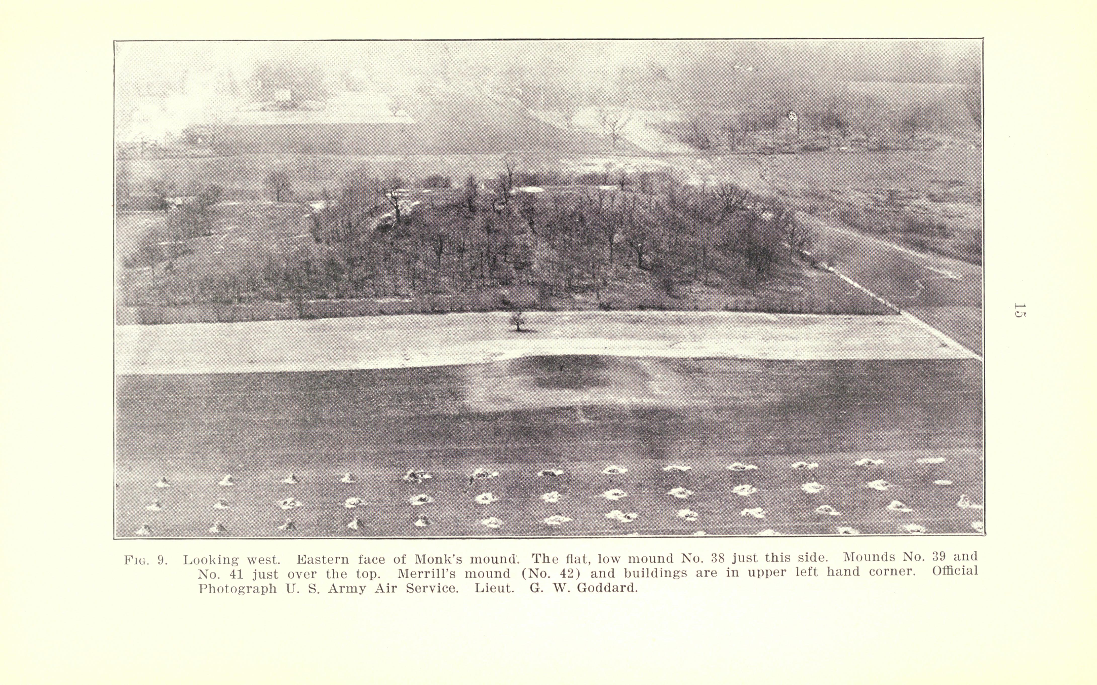
Aerial view looking west.
Monks Mound and eastern plaza.
From The Origin of the Cahokia Mounds by A. R. Crook, 1922.
As Monks Mound was completed in the early part of the twelfth century, a large building, some 100 feet long by nearly 50 feet wide, was constructed at the north end of its summit (Figure 1). The large wall posts were placed in a trench excavated to a depth of 3 feet, and a series of large poles were aligned along the center axis to support a massive horizontal ridge pole. The building’s height added another 40 feet to the top of Monks Mound. In front of the building, a substantial pole was erected in a large hole that was 15 feet in depth, and the pole arose above the roof of the building and could readily capture the spiritual forces that erupted around the mound during the spring and summer. It was in the top of the pole where the thunderers resided. This building at the center of the site may have been a metaphor for the sub-clan, the “House in the Middle” of the Osage sky chief, which several centuries earlier was situated at the center of certain Emergent Mississippian villages.
By the end of the twelfth century something had happened. A large palisade was constructed to enclose Cahokia’s most sacred elements, Monks Mound and the Grand Plaza (Figure J). People were mobilized to construct a wooden wall with circular bastions at regular distances along the wall. A wall was also erected at the center of the ancient town at what is now East St. Louis, and the residential area outside was set afire. Its residents rapidly dispersed. Some were able to construct temporary shelters within the walls at the town’s center. Items that may have been possible weapons were left behind, suggesting they may have been driven from here as well. The only possible force that could have overrun the area of East St. Louis was Cahokia. The picture is very unclear.
Nonetheless, we begin to see other actions being taken at this time. The building on the summit of Monks Mound was abandoned, removed, and symbolically buried. We see similar activity associated with many of the other larger mounds as they were turned into monuments. The woodhenge monuments to the west were no longer being rebuilt, and by the beginning of the thirteenth century this area had reverted back to a small residential area. The Powell area precinct on the western margin of the site was essentially abandoned. The population at Cahokia and the region had been cut in half by this time, but Cahokia remained the largest Mississippian town as the Mississippian world began to explode on the scene further south and east.
In addition to building the palisade, Cahokians began to add a large terrace onto the south face of Monks Mound, and a small mound was placed at the southwest corner of the mound with a sequence of temples constructed on its summit. Outside the palisade wall, a new plaza complex was built. Second in size to the Grand Plaza, the newly created Ramey Plaza was constructed from earth obtained from a residential area to the north of the plaza. Earthen platforms serve to accentuate the plaza and its sunken nature some four to five feet below the surrounding landscape. Today, as one drives through the subdivision superimposed on the east half of the plaza, one encounters a major bump in the road that drops into the plaza. This bump is part of an earthen berm—extending along the north edge of the plaza—that was excavated to create the sunken plaza to the south. A series of mounds were placed along the north edge. On the west, the platform was constructed with earth that caps a sacred landscape of special buildings, including a copper workshop, and upon which rectangular, earthen mounds were erected. However, between the completion of the platform and the mound building, a torrential flood occurred throughout the valley. A massive deposit of silts and sands from the Mississippi River extended across the top of the platform, sealing off its surface.
This flooding occurring in the early to mid-thirteenth century provided the first clear evidence of a catastrophic event not only at Cahokia but also in the surrounding region. What time of the year did this occur? And how did it affect the people? The most likely time for flooding to occur would have been the spring. Undoubtedly the taller mounds, those over 5 to 10 feet and above, would have stood above the waters. Whether people would have had access to them is uncertain. After the flood, we do know that Mound 34 was completed, and a large building perhaps 35 to 40 feet square would have highlighted the summit. It would have been the place in which rituals related to hunting and warfare were conducted. Again something devastating took place, and the building burned. It is unclear whether this was intentional, an act of aggression on the part of others—or perhaps the result of nature, the building struck by lightning and burned. Regardless, this event necessitated the removal of the building’s architectural elements, which were deposited, with its contents, over the sides and onto an earthen terrace below. The summit was then capped as a final act of symbolic burial, thus creating a monument.
By the end of the thirteenth century, Cahokia had become an altogether different place. Mounds were no longer being constructed, and the existing mounds had become earthen monuments. The West Plaza, a residential area in the early thirteenth century, was abandoned after the flood. It was later reoccupied by the beginning of the fourteenth century, continuing as a large residential area until the site’s abandonment later in the fourteenth century. Cahokian society had reverted back to a tribal society, and this may have been the onset of the ethnogenesis of groups such as the Quapaw and Osage, undoubtedly some of which were descendants of the original society.
Some four centuries later, in January 1810, Henri Marie Brackenridge traveled to Cahokia from the small town of St. Louis. His journey by horse took him across the Mississippi on the Wiggins Ferry that docked at Illinoistown, today located near East St. Louis’s Higher Education Center. Once he reached the higher ground, he climbed the highest mound in the East St. Louis mound group. From there, he saw in the prairies around him an estimated 45 to 50 earthen mounds that formed a large semicircle opening upon and facing Cahokia Creek to the west. His further journey along the ancient trail led him to the Cantine Mounds where the Trappist Monks had settled around the Great Knob. Again, climbing to the top of the Great Knob, he could easily count over 60 mounds in the surrounding prairies. This must have been an impressive panorama that excited the imagination of Brackenridge and continues, through his account, to excite others even today.